On Blackpowder and Deer
August 12, 2026
I’ve found myself getting pulled back toward black powder lately.
I’ve always had a soft spot for it, but lately that interest has turned into
something more substantial. Part of it is the firearms themselves. There’s
something satisfying about the slower, more deliberate process of loading,
shooting, cleaning, and actually having to know what you’re doing. Part of
it is the history, and part of it is just wanting to put a couple of old
rifles I already own (A percussion cap Hawken and a flintlock Kentucky Rifle)
back to work instead of letting them sit in the safe.
I think hunting is what really brought it all back around. I’ve been thinking
more seriously about getting out into the woods and eventually putting some
meat in the freezer. I’m not sure yet if I’ll actually make it out this
season. There’s still plenty to learn, re-learn, scout, buy, fix, and generally get
my ducks in a row. If it doesn’t happen this year, I’m perfectly happy to
spend the season getting ready for next year.
There’s something appealing about taking game the old fashioned way, at least to
some degree. Not because modern equipment doesn’t have its place, but because
I like the idea of actually learning and using the skills required with black
powder.
And honestly, there’s a little unfinished business involved. My 14 year old
self had big ideas about this sort of thing, but didn’t exactly have the
patience or toughness to see them through.
I’m a little older now, and hopefully a little wiser. Maybe this is just my
chance to finally outdo that 14 year old kid and bring home a deer this time.

Things I Miss That Don't Exist Anymore
August 06, 2026
Nostalgia has a way of sanding off the rough edges. I know not everything on
this list was actually better. Some of it probably wasn't. But there was
something about these places and things that made the world feel a little
bigger, a little more optimistic, and a lot more interesting.
-
Microsoft Encarta

Wikipedia is objectively a better reference. It has more information,
it's constantly updated, and it's free. I still miss Encarta. There was
something satisfying about exploring a digital encyclopedia that felt complete. You'd start reading about the Civil War and somehow end up looking at volcanoes or Roman aqueducts an hour later. It felt like wandering through a museum instead of searching a database.
-
LL Bean and Eddie Bauer Catalogs

Every season there was a new catalog to flip through. Even if you couldn't
afford a thing in it, you studied every page. The photography made ordinary
camping trips look like grand adventures, and the clothes looked like they
were built to last a lifetime. They sold an idea as much as they sold gear.
-
Dining In at Pizza Hut

Red cups. Tiffany lamps. The smell of fresh pizza when you opened the door.
A pitcher of Pepsi on the table. It felt like an event instead of just
picking up dinner. Modern Pizza Hut isn't the same place, and that's a shame.
-
Radio Shack

If you wanted a resistor, a soldering iron, a connector, or a random switch,
there was a place you could drive to and buy one today. I probably spent more
time looking through the parts drawers than I did buying anything. There
just isn't an equivalent anymore.
-
TOY Stores

Walking into a toy store felt like stepping into another world. You weren't
looking at a couple aisles squeezed into the back of a department store.
The whole building was toys. Board games, model kits, trains, action figures,
Legos, puzzles, and things you had never seen before. Half the fun was
wandering around with no particular goal.
-
Optimistic Advertising

Old advertisements sold the future. New appliances meant more time with your
family. A station wagon meant road trips. Camping gear meant adventures.
Even when they were trying to sell you something, they assumed tomorrow was
going to be better than today. Modern advertising mostly tries to make you
feel inadequate before offering a solution.
-
Browsing Without an Algorithm

Libraries, bookstores, encyclopedias, catalogs. You discovered things by
accident because something happened to catch your eye. The internet gives
us exactly what we ask for, but it doesn't always show us what we didn't
know we were interested in.
-
Department Stores That Sold Quality Outdoor Gear

Sears, Montgomery Ward, and mom-and-pop stores like Sunny's sold honest outdoor gear that
regular people could afford. Maybe it wasn't the lightest or the fanciest,
but it worked. You could buy fishing tackle, boots, camping gear, and tools
in one trip without everything feeling like luxury equipment.
Maybe that's the common thread. None of these things were perfect. They simply
invited you to slow down and look around. They encouraged curiosity instead of
urgency, repair instead of replacement, and experiences instead of convenience.
I don't think I miss the past as much as I miss that feeling.
On Backpacks and Spreadsheets
July 23, 2026
This whole thing actually started because I wanted to get into rucking.
It seemed like a good excuse to get outside, get some fresh air, and
hopefully lose a few pounds without feeling like I was just exercising
for the sake of exercising.
I dug my old Teton Scout out of the closet, figuring it would be perfect.
It had been sitting for years, but I didn't think much of it. I picked it
up by one shoulder strap and rip. The webbing gave way
immediately. Fifteen years in a closet had apparently done more damage
than years on the trail ever had.
I contacted Teton Sports to see if they could repair it or sell me
replacement straps. They couldn't do either, but they did offer me 20%
off a new pack. I appreciated the offer, but buying another internal frame
pack wasn't really what I wanted.
Instead, I found myself thinking back to Royal Rangers. I spent a lot of
time camping and hiking through the Assemblies of God scouting program
growing up, and somewhere along the way I decided I wanted an old external
frame pack again.
After a few days of browsing Facebook Marketplace, I found a Camp Trails
Adjustable II for $30. It was dirty (really, really dirty!) but complete.
The first stop wasn't the trail. It was the bathtub. After scrubbing what
had to be twenty-five years of dirt, dust, and who knows what else off
of it, I finally had a backpack again.
Of course, having a pack immediately led to another question: what would
it actually take to build a backpacking kit?
I started making lists on paper, crossing things out, moving things
around, and rewriting them. It didn't take long before I admitted this
was a spreadsheet problem.
Over the next couple of days I gathered every camping item I could find
around the house. Some things hadn't been used in years, some I'd forgotten
I even owned, and some were leftovers from car camping. Every item went
into the spreadsheet.
The sheet turned into much more than a packing list. Every item is
categorized, with its weight, cost, and any notes I want to keep.
It's easy to sort by shelter, sleep system, cooking gear, clothing, tools,
hygiene, or whatever else I'm looking at.
I also split everything into three worksheets. One tracks my core
weight, the gear that goes on every trip. Another keeps up with consumables
like food, fuel, water, and toiletries. The final sheet pulls everything
together.
The totals page is probably my favorite part. I added a few formulas so
I can select how many days I'll be on the trail and automatically
calculate how much food to pack. Another section estimates an appropriate
trailhead pack weight based on body weight, using drop-down menus so I can
quickly compare where I'm at against different backpacking recommendations.


Was all of that necessary? Probably not.
Was it fun? Absolutely.
It's also been interesting seeing just how much of a backpacking kit
I already had. I haven't bought nearly as much as I expected because I
started by using what was already in the house. As I get back into the hobby,
I'll replace things one piece at a time as they wear out or as I find
something that offers a real improvement.
For now, though, the goal is simple: quit staring at the spreadsheet,
get out on the trail, and see what actually works.
On Shelf Clouds
July 10, 2026
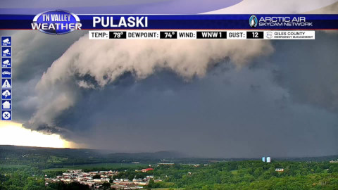
On my way home yesterday I was treated to one of the more impressive weather
sights I've seen in a while: a shelf cloud stretching across the horizon.
I've seen a few of them over the years, but they never fail to catch my
attention. Unfortunately I wasn't in a spot where I could safely pull over
and get a picture, but the folks over at TN Valley Weather managed to capture
a great shot that looked almost exactly like what I saw.
That sent me down the inevitable rabbit hole. I knew what a shelf cloud was
in general, but I realized I couldn't confidently explain the difference
between a shelf cloud and a wall cloud. As it turns out, they're almost
opposites despite being confused with one another all the time.
According to the National Weather Service, a shelf cloud forms along the
leading edge of a thunderstorm where cool outflow from the storm forces warm,
moist air upward. They tend to be long, wedge-shaped, and are usually a sign
that strong winds and heavy rain are just minutes away. Wall clouds, on the
other hand, form beneath the rain-free base of a supercell in the storm's
inflow region. Rather than signaling outflow, they mark an area of strong
updraft and can sometimes precede tornado formation. One of the easiest ways
to tell them apart is that shelf clouds move out ahead of the rain, while
wall clouds generally remain attached to the storm's updraft region.
If you'd like to learn more, the National Weather Service has an excellent
comparison of the two cloud types:
Shelf Cloud versus a Wall Cloud
.
One of my favorite things about nature is that there's always something new
to learn. Sometimes all it takes is looking up on the drive home.
On Heatwaves and Creativity
July 1, 2026
Much like my last post, weather has forced me to stay indoors during my
downtime. With temperatures reaching the mid-90s and the heat index
exceeding 105°F this week, I am more than thankful for air conditioning
and the joy of tinkering on Neocities.
I've had the distinct pleasure of being offline for several months and
enjoying the outdoors both with my family and on a few solo adventures.
I have been made keenly aware of the absolutely stunning beauty of
Tennessee's state parks and plan to make more use of them in the months
and years to come.
One thing Mrs. K4ZZA and I have been doing to pass the time is daydreaming
about future family trips and planning things out...
ONWARD AND UPWARD!
Ice, Solder and DMR Contacts
January 24, 2026
We're currently in the throes of what may shape up to be a historic
ice storm! What that means practically is that the roads are all
closed and I've got plenty of time to spend on soldering projects,
ham radio, and Star Trek.
Today I assembled a little clock kit I ordered from China...
All said, not a bad start to what may turn out to be an extended
snow vacation.